| Crow Canyon Archaeological Center |
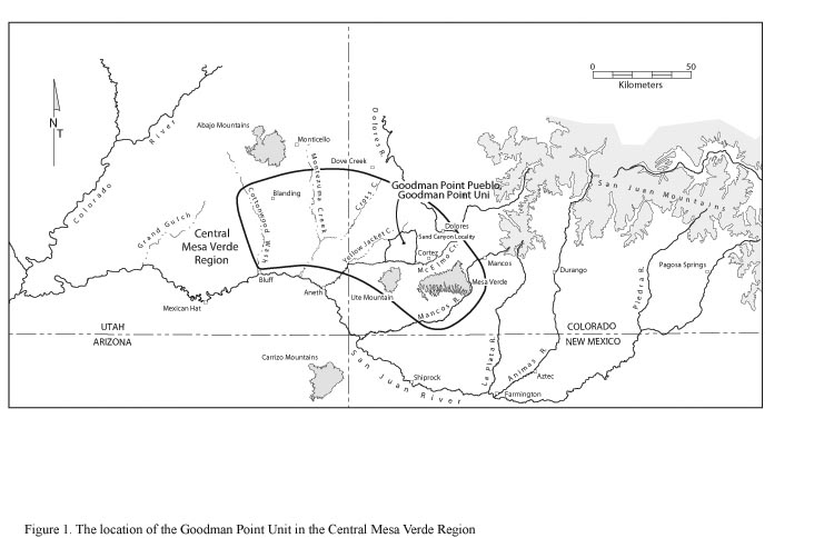
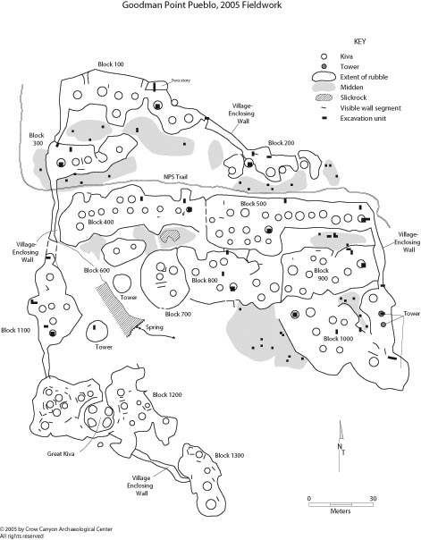
Report of 2005 Research at Goodman Point Pueblo (Site 5MT604) In November 2005, the Crow Canyon Archaeological Center completed the first year of the Goodman Point Archaeological Project: Community Center and Cultural Landscape Study. This project will entail six years of research at the Goodman Point Ruins Group Unit of Hovenweep National Monument. The first phase of the project will include three years of excavation at Goodman Point Pueblo (Site 5MT604), the largest site in the Goodman Point Unit. During the second phase of the project, also three seasons in length, research will be conducted at several other locations in the Goodman Point Unit including a variety of smaller habitations, roads, and possible agricultural fields. This report summarizes the work that Crow Canyon completed at Goodman Point Pueblo in 2005 and includes a description of research goals and strategies, descriptive and interpretive excavation summaries, a record of American Indian involvement, and research plans for the 2006 field season. IntroductionGoodman Point Pueblo (Site 5MT604) is a large ancestral-Pueblo village site in the central Mesa Verde region ( Figure 1). The site is located along the eastern margin of a cluster of Pueblo III (A.D. 1150–1300) village sites stretching from Hovenweep National Monument in the west to Yellow Jacket and Castle Rock pueblos to the north and south, respectively. Goodman Point Pueblo lies approximately six kilometers northeast of Sand Canyon Pueblo, and occupies a position along the western rim of Goodman Canyon, which ultimately drains south into McElmo Creek. The site is situated in a canyon-head setting, occupying both pinyon and juniper tableland and steeper, sagebrush-covered slopes adjacent to a spring at the head of the canyon. This perennial spring, called Juarez Spring, flows northwest to southeast through the south-central portion of the site and was probably the primary source of domestic water for residents of the village. Goodman Point Pueblo contains 13 roomblocks, a minimum of 107 kivas, one great kiva, at least one bi-wall complex, several towers, and a semi-continuous village-enclosing wall. Numerous other habitation sites and cultural features dot the surrounding landscape. There is evidence that several of the roomblocks at the pueblo were multi-story, making accurate room counts difficult. However, 500 to 750 people might have occupied the village at its zenith. On the basis of observations made during the 2005 field season, the field staff infers that the tested portions of Goodman Point Pueblo date from the late Pueblo III period, which spanned the years A.D. 1225 to 1285. History of the UnitThe Goodman Point Unit contains the first archaeological resources set aside for protection by the federal government. In 1889, Section 4, Township 36 North, Range 17 West, which contains the Goodman Point Unit, was reserved from homesteading. This action was the result of a recommendation by W. D. Harlan, a U.S. Surveyor General in Denver, Colorado. In 1951, President Harry Truman reduced the size of the protected parcel to 62 acres within the section and designated this area as part of Hovenweep National Monument. An additional proclamation in 1952 added the additional acreage to compose the present unit, which is now managed by SEUG-NPS, Hovenweep National Monument. The use of the name “Goodman” in place names in this area originated from a foreman of the Lacy Cattle Company named Henry Goodman, who brought 5,000 head of cattle through the area in 1870 but never settled in the locality. Because the land has been protected since 1889, sites within the Goodman Point Unit are in nearly pristine condition (Connolly 1992). Archaeologists from Crow Canyon conducted noncollection pottery tallies at Goodman Point Pueblo in 1986. To obtain a general idea of the occupational history of Goodman Point Pueblo, the tallies were combined with data resulting from an analysis of sherds gathered during previous NPS collections. The results indicate that there was a limited occupation of the site during the Pueblo II period and a major occupation during the Pueblo III period (Adler 1986). One of the main goals of Crow Canyon’s proposed research is to refine the chronology of this important site. Using a plane table and alidade, Crow Canyon archaeologists mapped Goodman Point Pueblo in 1987. They also conducted a pedestrian survey of the Goodman Point Unit as part of a larger survey of the Sand Canyon locality (Adler 1988, 1990, 1992). This survey focused on residential sites dating from the Pueblo II and III periods, and 17 such sites were recorded at the Goodman Point Unit during this early survey. In 2003, Crow Canyon and the SEUG-NPS conducted a detailed pedestrian survey of the entire 142 acres of the Goodman Point Unit, and a total of 42 sites with 56 temporal components were recorded (Hovezak et al. 2004). The site density is thus one site per 3.4 acres, or 189 sites per square mile, which is one of the highest recorded densities in the northern San Juan region. The 56 temporal components identified during the survey include four that date from the Basketmaker III period, 15 that are of Pueblo II affiliation, and 23 Pueblo III components (Kuckelman et al. 2004). In 2005, the Crow Canyon Archaeological Center began a six-year project in the unit. The first year of that project is the subject of this report. Research Goals and StrategiesThe goals of our research at Goodman Point Pueblo reflect our multi-faceted approach to historical, anthropological, and methodological issues, as well as our commitment to American Indian interests. The following paragraph provides an overview of some of the broader questions we are addressing; a more detailed discussion of the research goals and objectives can be found in the research design created specifically for this project (Kuckelman et al. 2004). Our historical research goals include assessing the occupational history of the pueblo and determining when and how the village was depopulated. Anthropological research objectives include examining the settlement ecology of Pueblo farmers in the Mesa Verde region and analyzing how aggregation affects the internal and external organization of communities. Research goals designed to provide information important to American Indian interests include assessing the appropriate methods for studying relationships between archaeological cultures and modern groups and examining the processes that led to migration from the Mesa Verde region. Lastly, methodological research issues include large-scale goals, such as continuing efforts to produce fine-grained chronologies, and more specific goals, such as the use of petrographic analysis, to produce detailed models of intercommunity exchange. In order to achieve these goals, Crow Canyon archaeologists incorporate field methods and procedures that stress a conservation approach. The specific methods we use in the field are described in the Crow Canyon Archaeological Center Field Manual (2001). These practices are guided by the principles of conservation archaeology as outlined by Lipe (1974); namely, that most of the deposits on the site will be left intact for the future. Following from this philosophy, the only artifacts on the modern ground surface that we are collecting at Goodman Point Pueblo are those within excavation units; we are leaving in place all other artifacts in this context. Materials collected during the Goodman Point Archaeological Project will be analyzed according to the procedures outlined in the Crow Canyon Archaeological Center Lab Manual (Ortman et al. 2005) and temporarily curated at the Crow Canyon Archaeological Center until publication of the final site reports, at which time these materials will be transferred to a permanent curation facility. The size and the nature of specific remains we’re investigating and the type of information desired from specific contexts also guide the size and placement of test units (Figure 2, Table 1). To facilitate comparisons between different architectural blocks, statistically comparable data from midden contexts is desirable. Therefore, we placed randomly selected 1-x-1-m test units (a minimum of five per architectural block) within areas that appeared, from modern ground surface, to be middens. Where we discovered a cultural feature or other cultural anomaly that required additional exposure, we added one or more additional 1-x-1-m tests units adjacent to the original unit. For a variety of reasons we excavated larger units in structural areas and placed them judgmentally. In kivas, we located each 2-x-2-m unit in the southern portion of an observable kiva depression so that we could document architectural features typically found in the southern part of a kiva (e.g., pilasters, southern recess, ventilator tunnel, deflector, and hearth) and sample the contents of the hearth. By placing excavation units in these locations, we were able to collect data relevant to site architectural patterns, subsistence, kiva-related activities, and abandonment style. We also placed judgmental 1-x-2-m excavation units to test surface structures, the north walls of roomblocks, and village-enclosing walls. These test pits revealed a variety of architectural elements and cultural deposits. The primary purpose of north-wall and enclosing-wall units is to document architectural styles and patterns as well as occupational sequences at the site; units in surface structures also yield important information concerning structure use and abandonment practices and events. Though we tested only kivas, rooms, north walls, enclosing walls, and middens in 2005, we will investigate the great kiva and other types of non-residential buildings in upcoming seasons. 2005 Field SeasonThe 2005 field season began April 4, when the field staff began mapping the pueblo. Under the guidance and supervision of Crow Canyon staff members, program participants middle-school age through elderly adult excavated at the site from May 4 until October 7, and field staff closed the site for the winter on November 21. MappingOur initial task was to produce an accurate map of the site. We accomplished this task using a Topcon GT-303 electronic total station surveying instrument and AutoCAD software. Using numerous instrument-established datums, we mapped kiva depressions, observable wall segments, the NPS trail, Juarez Spring, areas of exposed bedrock near the spring, and the extent of rubble for each roomblock. We mapped 107 kivas, 13 architectural blocks, and many exposed wall segments and midden areas. This map provided a very accurate visual model that we used to delineate and number architectural blocks, define midden areas, and select locations for judgmental excavation. We also used the total station to shoot in test pits. As we mapped the site, we assigned a unique number to each architectural block. Crow Canyon defines an architectural block as a roomblock and its associated kivas, middens, and other extramural areas. This designation facilitates and organizes the documentation of the site and the resulting analytic data. At Goodman Point Pueblo, we numbered the blocks from north to south; the northernmost block is Architectural Block 100 and the southernmost is Block 1300. ExcavationsTable 1 summarizes, by architectural block, the excavation units opened in 2005. The table also specifies which units were completed in 2005 and which will be completed in 2006. In 2005, we opened 78 test pits: 10 kiva units, 16 surface structure units, eight units along roomblock north walls, three enclosing-wall units, and 41 midden units. We completed 30 of these units in 2005. In an attempt to obtain a representative sample from the entire site, we are excavating test pits in every defined architectural block. During the 2005 excavation season, we conducted testing in Architectural Blocks 100, 200, 300, 400, 500, 800, 900, 1000, and 1100. By the close of the 2005 field season, we had fully documented and backfilled each completed unit. We placed a layer of moisture- and vapor-permeable Geotek fabric against all exposed architectural surfaces before backfilling. We were careful to place rocks gently against exposed architecture, and to fill each unit with rocks and sediment removed from that particular unit. We tamped the fill to reduce settling and returned the top of the fill much as possible to the original appearance of the unit at modern ground surface. After covering each ongoing unit with a plywood cover and plastic sheeting, we encircled the unit with flagging tape tied to nearby vegetation. These safety precautions also serve to protect the units from damage by the elements during the winter. In the following text, the 2005 excavations are summarized by architectural block. The quantity and location of the units excavated during this season reflect our focus on the northern and eastern portions of the site; in future investigations, our emphasis will shift toward the central and southern areas of the site. Only those blocks tested in 2005 are discussed below. Architectural Block 100Architectural Block 100 is the northernmost block within Goodman Point Pueblo. Block 100 is approximately 65 m long east-west, and contains either eight or nine kiva depressions. Of the 10 units in this block, five were completed in 2005. Architectural Block 200Architectural Block 200 is located along the northeast edge of the site. This architectural block measures approximately 45 m east-west and comprises more-discrete clusters of surface structures than do other architectural blocks at the site. Five kiva depressions are located within Block 200. We completed eight of the 11 excavation units in this block in 2005. Kiva 207, which we completed this season, yielded interesting data and contained a large amount of collapsed masonry wall fall from the south wall of the associated roomblock. This is the only unburned kiva we’ve tested at the site thus far. The unit that exposed the north wall of the roomblock contained the deepest extramural deposits found to date and contained flaked lithic debitage as much as one meter below the base of the roomblock wall. This material was probably deposited before the village was constructed. Room 205 contains a dismantled subfloor feature that appears to have been a metate bin. Architectural Block 300Architectural Block 300 is situated in the western portion of Goodman Point Pueblo, just north of the NPS trail that bisects the site east-west. The block measures approximately 42 m east-west and contains four kiva depressions. We completed seven of the eight excavation units in this architectural block in 2005. We tested and documented Kiva 307, collecting approximately 40 tree-ring samples from this burned structure. In addition to these artifacts, we recovered a large portion of a black-on-white bowl from the floor, a small axe and cylindrical stone bead from the bench, and some of the ash from a remodeled, stone-lined hearth. Room 308, northeast of the kiva, yielded important data concerning the height of the roomblock in this area—the walls of this structure were approximately 3 meters tall. A large pit feature of unknown use and an in situ vertical slab that appeared to be part of a metate bin were associated with the floor of this room. One of the five midden units completed in 2005 revealed interesting details about kiva construction practices and depositional events. This unit, located south of Kiva 307, contained redeposited native sediment and rubble used as construction fill. This fill formed a berm that enclosed the southern portion of the kiva. In the unit that exposed the north wall of the roomblock, we observed that the village-enclosing wall abuts the north wall of the roomblock; this indicates that this section of enclosing wall was built after this roomblock. Both walls rest on construction fill intended to level their bases. Architectural Block 400Architectural Block 400 is located in the west-central portion of Goodman Point Pueblo, just south of the NPS trail that bisects the site east-west. This block is part of a larger architectural unit that extends nearly the entire width of the site; our division between Blocks 400 and 500 is largely arbitrary and intended to facilitate uniform sampling across the site. Block 400 contains 12 kiva depressions and stretches 68 m east of the western village-enclosing wall. Our testing of this block thus far has consisted of the excavation of three units, one of which was completed in 2005. Kiva 405, which was burned, has yielded about 27 tree-ring samples thus far. We excavated Room 404, northwest of this kiva, to the abandonment-period floor surface, revealing the southwest corner of the room and many floor artifacts. The unit designed to expose the north wall of this block actually contained part of another room (Room 406) that appears to have been added to the outside face of the north wall of Block 400 after the block was constructed. Architectural Block 500Architectural Block 500 is located in the east-central portion of the site and is the eastern part of the large architectural expanse that includes Block 400 to the west. This block contains 20 kiva depressions and extends approximately 78 m from the boundary of Block 400 on the west to the village-enclosing wall on the east. This architectural block is the one of the best defined and most spatially extensive architectural blocks at the site. In this block we’re excavating 12 units; we completed four of those in 2005. Because of the large size and possible temporal depth of this block, we tested two kivas there, one at the northeast end of the block (Kiva 501) and one near the southwest edge of the block (Kiva 506). We completed testing of both kivas during the 2005 field season. Both structures were burned, yielding numerous tree-ring samples and abandonment-period artifacts. We also completed our test pit in Room 505, which revealed important architectural details and yielded a complete axe and other diagnostic artifacts. The unit that exposed the north wall of this block is ongoing, and we were able to complete only one midden unit in this block. However, test excavations in this midden area revealed some of the densest midden deposits sampled at the site thus far. We also exposed an unusual courtyard feature that will be investigated more completely next year. Architectural Block 800Architectural Block 800 is located in the central portion of the site, northeast of Juarez Spring and immediately east of Block 700. The east edge of the tallest rubble mound at the site, that of Block 700, forms the west edge of Block 800. We have begun excavating eight units in Block 800; these will be completed in 2006. Unlike other kivas we’ve tested thus far, Kiva 807 appears to contain midden-like refuse; the structure might have been used for refuse disposal after it was abandoned. If so, this might indicate that structures in this part of the village were constructed earlier than those in other tested areas. Room 806 has yielded data important to understanding village topography and the construction methods used on the steep slope north and northeast of Juarez Spring. It has also produced information about surface structure roofing methods and the structural use of natural features such as bedrock. The midden deposits we tested on the slope to the south are relatively shallow. We will complete all excavation units in this block in 2006. Architectural Block 900Architectural Block 900 is located in the east-central portion of the site, adjacent to the eastern village-enclosing wall just south of Block 500. This discrete architectural block contains nine kiva depressions and is about 43 m long east-west. We completed five of the nine test pits in this block in 2005, including the test pit in Room 907 and the unit along the north wall of the roomblock. Excavations in Room 907 revealed a well preserved segment of the south wall of the room and also exposed an abandonment-period floor assemblage. The excavation unit designed to expose the north wall of the roomblock actually revealed the finished northwest corner of Room 907 and a linear masonry feature of unknown use. Kiva 902, which is partly burned, contains compact gray clay not observed in any other structure at the site thus far. At present we’re not certain of the source of this clay or how it was deposited. Next season, we should learn more about the construction of this kiva and how it filled. A test pit across a section of the east village-enclosing wall revealed that this wall was massively constructed and was at least one story tall. Refuse had been deposited against the inside, but not the outside, face of this wall. We also completed four midden units in Block 900. These units extended the deepest subsurface of any midden units excavated to date at the site and were also some of the most artifact-rich. Several of the midden units in this area contained a thick layer of gray ash, which is unusual for this site as a whole. The data generated by this refuse will no doubt prove invaluable for reconstructing prehistoric life at the pueblo. Architectural Block 1000Architectural Block 1000 is located at the extreme southeastern edge of the site. This block contains a minimum of nine kiva depressions and includes a small tower complex adjacent to the outside face of the village-enclosing wall at the southeastern edge of the block. All 11 units in this architectural block are ongoing. We recovered several tree-ring samples from the burned roof fall in Kiva 1007. The test pit in the tower (Structure 1010) contained important information about the shape and orientation of this structure at the southeast edge of the village. Testing of an additional possible tower (Structure 1002), this one adjacent to the inside face of the village-enclosing wall, revealed ambiguous architecture that may indicate that the structure was actually a kiva; we hope to resolve this issue when this unit is completed in 2006. Excavations in Room 1011 and along the north wall of the roomblock yielded information important to understanding the layout and orientation of this block, which has proved difficult to discern from indications at the modern ground surface. All midden units in this block are ongoing and are generating important data regarding site chronology and cultural practices in the village. Architectural Block 1100Architectural Block 1100 is located along the western margin of the site between two drainages that converge at Juarez Spring. The long axis of this block is aligned roughly north-south and is the only block at the site so oriented. The block contains six kiva depressions and stretches about 42 m along the western edge of the site. We have not yet determined how this block and the village-enclosing wall interface. The sections of village-enclosing wall that span the drainages at the north and south ends of the block would, by definition, have served as dams. Five of the six excavation units in this block are ongoing. We completed excavations in Room 1102. Excavators exposed portions of the east and south walls of this multistory room located in the southern portion of the block; we found a small abandonment-period assemblage on the floor. As in other areas of the site, data from this room indicate that the villagers built two-story roomblocks with relatively large rooms in some areas of the village. Other testing in this block revealed part of a bi-wall structure (Rooms 1106 and 1107). A small row of semi-rectangular rooms surrounds an untested circular structure. This find was unexpected because the bi-wall layout was not observable at the modern ground surface. Also, because there appears to be a large bi-wall structure west of the great kiva in Block 1200, we did not expect an additional structure of this type at the site. Work will continue in the bi-wall structure in Block 1100 in 2006. Other unfinished units in Block 1100 include a pit that exposed a section of village-enclosing wall or dam, a unit in Kiva 1101, and a test pit in what was an isolated room or tower. Kiva 1001 was partly burned at or near the time of abandonment, and we collected several tree-ring samples from this structure. Evidence from Room 1103 indicates that this might have been an kiva built inside an above-ground masonry surface room. We observed organic deposits near the bottom of the village-enclosing wall/dam unit that seem to be sediment, probably deposited alluvially, that accumulated against the feature. We will complete these units in 2006. Summary and InterpretationsThe first field season of research at Goodman Point Pueblo was very successful in obtaining data to address research goals. Our high resolution map of the entire site, documentation of individual excavation units, collections of artifacts and samples, color and black-and-white photographic images, and detailed stratigraphic information provide a solid foundation for interpretations of this important late Pueblo III village. Stratigraphic and construction data yield important chronological and demographic information. The presence of shallow middens and the absence of refuse from the fills of nearly all structures tested thus far suggest that the village was occupied for a relatively short period of time. Most structures rest on bedrock. Builders constructed kivas from bedrock upward—some kivas were constructed within a rectangular masonry structure, others were enclosed by large berms around their peripheries. Excavations in rooms have revealed that many structures in the village were two stories tall. We calculated the original heights of several structures using the existing height of the walls and the volume of rubble removed from inside the structures during excavation. With this information, we can compare the heights of the tested mounds with the heights of untested mounds to estimate the original heights of the untested roomblocks. For example, we can now state with a fair degree of certainty that Block 700 was at least three stories tall. We'll work in this block during the 2006 field season. Public InvolvementDuring the 2005 field season, a large and diverse segment of the interested public benefited from Crow Canyon’s field research. The excavation portion of the project involved 710 participants comprising 213 adult and 497 high school age or younger students. Approximately 600 additional people visited the site through Crow Canyon-sponsored day tours, education programs, and other special site-touring events that did not include excavation. Also, a minimum of 309 drop-in visitors received a map and information about the site from Crow Canyon personnel during the excavation season; many of these people were not formally affiliated with Crow Canyon, and this figure largely represents interested members of the general public who visited the site as a recreational or educational experience. In sum, approximately 1,619 people either participated in Crow Canyon-sponsored research at the site or were in some way informed about the prehistory of the region as part of the 2005 field season at Goodman Point Pueblo. This figure reflects both Crow Canyon’s commitment to involving diverse segments of the interested public and the public’s considerable interest in the ancient past of the Mesa Verde region. All research and education conducted at the site was made possible through the cooperative partnership between Crow Canyon and the NPS. American Indian InvolvementAmerican Indian consultation is an important part of the research process at the Crow Canyon Archaeological Center. On April 30, 2005, Ernest M. Vallo Sr., who is of Acoma affiliation and is also a member of the Crow Canyon Native American Advisory Group, conducted a blessing ceremony before our excavations at Goodman Point Pueblo began. Individuals of both Hopi and Alutiiq affiliation attended this ceremony. During the 2005 field season, representatives of 11 different tribal groups visited Crow Canyon’s excavations at Goodman Point Pueblo. The following pueblos were represented: Acoma, Jemez, San Ildefonso, San Juan, and Taos. The Alutiiq, Hopi, Navajo, Northern Ute, Ute Mountain Ute, and White Mountain Apache were represented as well. Specific tribal organizations involved in these visitations include the Hopi Cultural Preservation Office, the Hopi Foundation, the Jemez Cultural Preservation Office, the Tiwa Culture and Language Camp, and the Ute Mountain Ute Youth Opportunity Program. The endorsement of the blessing ceremony by both the Crow Canyon Archaeological Center and the National Park Service, as well as our continued consultation and interaction with American Indian groups throughout the Goodman Point Project, demonstrate our commitment to archaeological field research and to facilitating communication with American Indian peoples. Human RemainsThough never sought as part of Crow Canyon’s research, we inadvertently discovered human remains during excavations in 2005. Our treatment of human remains on the Goodman Point Archaeological Project follows Crow Canyons official policy regarding the treatment of human remains and associated funerary objects as specified in our field manual (Crow Canyon Archaeological Center 2001). In compliance with our ARPA permit (number 05-HOVE-01), we notified the NPS promptly of all such discoveries. We recorded two human remains occurrences; these are remains that appeared, from limited exposure, to be at least partly articulated. Other remains were scattered or isolated, although because excavation in the vicinity of such remains was restricted after the first few elements were exposed, we could not determine the total quantities and types of bones in those locations. One occurrence of human remains consisted of a formal burial in a midden, nearly all other remains discovered were in abandonment contexts such as roof fall or wall fall. To ensure that all units containing human remains would be backfilled before winter, documentation of excavation units containing human remains received the highest priority. To our knowledge, no ongoing units contain human remains. We recorded the proveniences of human remains carefully and left all identified remains in their original depositional contexts. Kathy Mowrer, an osteological analyst employed by Crow Canyon Archaeological Center, conducted in-field analysis of all remains that were recognized in the field as human. Plans for the 2006 Field SeasonAlthough we have not finalized specific excavation plans for 2006, some general goals can be stated. Our first priority will be to complete and backfill units that were opened in 2005 and to shoot in additional units. The primary spatial focus of our new investigations will be the central and southern portions of the site, including Block 700 and blocks with public architecture such as Block 1200. We have been unable thus far to locate midden deposits for some architectural blocks; we will endeavor to locate, define, and test such middens. Also, in order to further define specific structures and to bolster midden data, we will place some additional judgmental units in blocks from which we have already gathered basic data. Within the parameters of our research design, we hope to maximize data recovery so that we will be able to address our research goals as fully as possible.
The Crow Canyon Archaeological Center's 2005 field and laboratory program related to the Goodman Point Archaeological Project was funded in part by State Historical Fund grants from the Colorado Historical Society.
Research Field Personnel, 2005 Field Season Kristin Kuckelman Project director Education Staff, 2005 Field Season Jennie Akers Other Staff and Volunteers Who Worked at Goodman Point Pueblo, 2005 Field Season Larry Berger
References Cited Adler, Michael. A. 1988 Archaeological Survey and Testing in the Sand Canyon Pueblo/Goodman Point Ruin Locality, Montezuma County, Colorado, 1987 Field Season. Crow Canyon Archaeological Center, Cortez, Colorado. Report submitted to the Bureau of Land Management, San Juan Resource Area Office, Durango, Colorado. Connolly, Marjorie R. Crow Canyon Archaeological Center Hovezak, Timothy D., Leslie M. Sesler, Mark D. Varien, and Chris Goetze Kuckelman, Kristin A., Mark D. Varien, Scott G. Ortman, and Jonathan D. Till Lipe, William D. 1995 The Depopulation of the Northern San Juan: Conditions in the Turbulent 1200s. Journal of Anthropological Archaeology 14:143–169. Lipe, William D. (editor) Ortman, Scott G., Erin L. Baxter, Carole L. Graham, G. Robin Lyle, Lew W. Matis, Jamie A. Merewether, R. David Satterwhite, and Jonathan D. Till Varien, Mark D. Varien, Mark D., and Richard H. Wilshusen See also: Report of 2006 Research at Goodman Point Pueblo (Site 5MT604), Montezuma County, Colorado REMINDER: Archaeological resources are protected by federal laws, and archaeological research is guided by a set of professional ethics. See Archaeological Ethics and Law. © Copyright 2006 by Crow Canyon Archaeological Center. All rights reserved.
|