


|
Architecture
by Kristin A. Kuckelman
1
The data generated as a result of Crow Canyon's excavations at Yellow
Jacket Pueblo (Site 5MT5) indicate that the site was inhabited for approximately
220 years (see "Chronology"). During
that time, a wide variety of structures were built, including residential,
ceremonial, and public; these include both single- and multiple-story
constructions, as well as above- and belowground structures. Numerous
extramural features, such as retaining walls, were also constructed, and
areas of open space might have served as outdoor public places. Detailed
descriptions, maps, and photographs of the structures and outdoor use
surfaces exposed during testing are contained in The Yellow Jacket
Pueblo Database, as are numerous interpretations regarding chronology,
function, and abandonment processes at the level of the individual study
unit. This chapter describes and interprets remains by architectural block
and for the site as a whole; it includes observations about unexcavated
structures that were viewed only on the modern ground surface, as well
as observations about structures exposed during excavation. At Crow Canyon,
we define an architectural block as a roomblock with its associated kivas,
midden areas, and outdoor surfaces and features. At Yellow Jacket Pueblo,
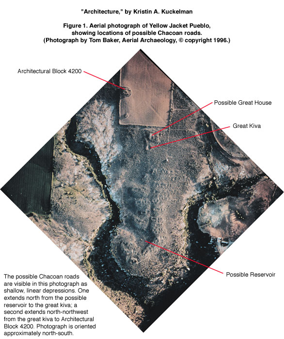
the exceptions to this definition are the probable great kiva (Block 1800)
and the possible reservoir in the south-central portion of the site (Block
2000) (Database Map 263).
Architectural Evidence Visible on the Modern Ground Surface
2
On the modern ground surface, indications of buildings include sandstone
rubble, the exposed tops of masonry walls, and topographic mounds and
depressions. The owners of all land on which the site is located granted
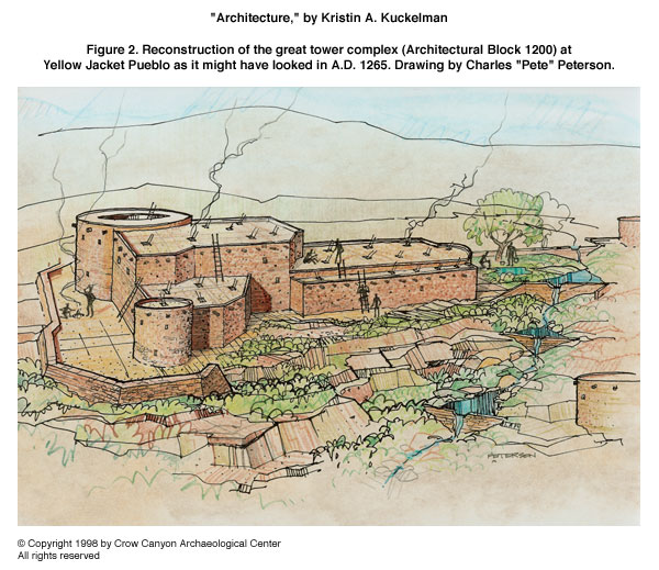
us permission to map these surface indications (Database Map 263),
and on the basis of the resultant data, I conclude that this approximately
100-acre site consists of at least 42 architectural blocks. Contained
within these blocks are an estimated 600 to 1,200 rooms, a minimum of
195 kivas, and at least 19 towers. The wide range estimated for rooms
is due to the large number of roomblocks at the site, the fact that individual
rooms are difficult to recognize from surface indications, and the probability
that some structures were two stories tall. Numerous features such as
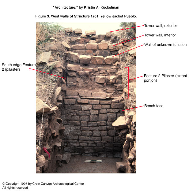
monoliths, petroglyphs, and isolated extramural walls and dams were also
observed and mapped. In addition, as part of Crow Canyon's Village Mapping
Project (Lipe and Ortman 2000*1),
aerial photographs were used to produce a topographic map of the site
(Database Map 265). This map and the aerial photographs were used
to establish the presence and locations of possible Chacoan roads associated
with the great kiva and to aid in the determination of the original horizontal
and vertical extent of each roomblock.
Roomblocks
3
Sandstone rubble is found in mounds, concentrations, and scatters at Yellow
Jacket Pueblo, and these remains are inferred to indicate the locations
of masonry roomblocks. Rubble mounds are found primarily on the upland
portions of the site; the rubble concentrations and scatters are located
predominantly on the talus slope beneath the canyon rim (roomblocks that
have collapsed on steeply sloping terrain usually do not present a mounded
appearance). The height of the rubble mounds visible on the modern ground
surface varies widely, from less than 0.3 m to 2.5 m, although these assessments
are somewhat subjective because the modern ground surface slopes in various
directions around the mounds. The lowest mounds are in Architectural Blocks
2800 and 3000, west and northwest of the great kiva, respectively; they
are not visible on the topographic map of the site, which is plotted at
30-cm contour intervals (compare the major cultural units map [Database
Map 263] with the site topographic map [Database Map 265]).
On the basis of the surviving heights of most rubble mounds at the site,
I infer that these, and most of the other roomblocks, were one story tall.
The tallest rubble mounds are in Block 1900 (the possible Chacoan great
house), Block 1200 (the great tower complex), and, in the southern one-third
of the site, Blocks 2600, 2500, and 200; at least portions of these roomblocks
were probably two stories tall. In fact, the great house could have been
three stories in height (see paragraph 16).
4
Although much of the variability in rubble mound size no doubt reflects
the original heights of the structures and the methods used to construct
them, the salvaging of building materials in both ancient and modern times
for reuse in other constructions also may have contributed to the observed
variability. The "recycling" of usable building materials is believed
to have been common practice throughout the Mesa Verde region prehistorically,
and it is well known that building stone was removed from Yellow Jacket
Pueblo for a variety of purposes in historic times. Porter
(1984*1:3) describes how stone was hauled away from the site in wagons
for use in local building projects. Landowner Arthur Wilson (personal
communication, 1995) recalled that the eastern portion of the rubble mound
associated with the possible Chacoan great house was removed during a
rock-crushing operation for road maintenance in the 1940s. According to
Mr. Wilson, this portion of the mound was taller than the remaining rubble
mound, which is 2.5 m in height (see the discussion of the great house,
paragraphs 15–19). The depression left by
the rock-crushing operation is visible on the topographic map of the site
(Database Map 265), to the east of the rubble mound in Architectural
Block 1900.
5
The estimate of 600 to 1,200 rooms at the site was derived from (1) the
horizontal extent of sandstone rubble at each rubble mound and scatter,
(2) the location and orientation of sections of visible walls within each
rubble mound, and (3) the average size of a few rooms that had been exposed
by previous, undocumented excavations in Architectural Block 1100. Many
of the roomblocks at Yellow Jacket Pueblo are linear and laid out in what
Lekson (1999*1:12) describes
as parallel "streets." This layout of "multiple, closely spaced, often
parallel aggregates of Prudden units" (Varien
et al. 1996*1:98) is typical of large villages in this region constructed
in the late A.D. 1100s. Although most of the roomblocks at Yellow Jacket
Pueblo appear to be oriented east-west, which is typical of blocks at
sites dating from the Pueblo II and III periods, the roomblocks built
against the cliff face on the talus slope below the canyon rim are probably
oriented to the cliff face rather to the cardinal directions. Also, the
roomblock in Architectural Block 100 is oriented northeast-southwest.
This unusual orientation could have resulted from the builders following
the natural topography of the northeast-southwest-trending ridge on which
the roomblock was built or could have been designed to create an astronomical,
or other significant, alignment (Malville
and Putnam 1989*1).
Kivas
6
Circular depressions at Yellow Jacket Pueblo are located both within and
immediately south of areas of roomblock rubble and therefore are inferred
to indicate the locations of kivas (earlier forms of subterranean structures,
such as pithouses, were not constructed within roomblocks, and they generally
were located farther away from the roomblocks than were kivas). Many kivas
at Yellow Jacket Pueblo appear to be "blocked-in"—that is, constructed
aboveground but within rectangular masonry enclosures. Others are partly
blocked-in, and some appear to be fully subterranean. The presence of
a great kiva was inferred from surface indications in the central portion
of the site; this structure is discussed in greater detail in paragraphs
20–21.
Room-to-Kiva Ratio
7
The ratio of rooms to kivas at Yellow Jacket Pueblo might have been lower
than average for this region and time period. Lipe
(1989*1:Table 1) calculates that there were nine rooms for every kiva
during the Pueblo III period (A.D. 1150–1300). Excluding the cliff
dwellings at Mesa Verde National Park, Varien
et al. (1996*1:99) estimate an average ratio of fewer than five rooms
to one kiva. On the basis of our mapping, I estimate that there are at
least 195 kivas and between 600 and 1,200 rooms at Yellow Jacket Pueblo.
The estimate of the number of kivas is much more precise than the estimate
of the number of rooms because kivas are larger than rooms and tend to
leave distinct depressions on the modern ground surface. Because the number
of rooms is difficult to estimate accurately, the exact ratio of rooms
to kivas cannot be determined. If there were 600 rooms at the site, the
ratio of rooms to kivas would have been 3:1, or 600 rooms to approximately
200 kivas. If there were 1,200 rooms at the site, the ratio would have
been 6:1. The latter is similar to the ratio of 5:1 estimated by Varien
and his colleagues but below Lipe's calculation of 9:1 for the Pueblo
III period.
8
The ratio of rooms to kivas can be estimated more accurately for the great
tower complex (Architectural Block 1200) because we tested numerous structures
in this block and we have additional information on numbers of structures
from the excavations by the Museum of Western State College in 1931 (Hurst
and Lotrich 1932*1:195). Built in the mid–A.D. 1200s, the great
tower complex was probably one of the latest constructions in the village.
The ratio of rooms to kivas is extremely low—approximately 1:1—which
could indicate some sort of special use. There is also evidence in the
faunal assemblage (see "Faunal Remains")
and the archaeobotanical assemblage (see "Archaeobotanical
Remains") of possible special use of this block.
9
The highest ratio of rooms to kivas at Yellow Jacket Pueblo appears to
have been in the possible Chacoan great house (Architectural Block 1900;
see paragraphs 15–19), where only one kiva
depression was observed but numerous rooms were present. It is difficult
to estimate the number of rooms that this block originally contained,
because the block appears to have been multistory and its eastern portion
was largely destroyed, reportedly in the 1940s (Arthur Wilson, personal
communication 1995; see paragraph 4). Nonetheless,
there were clearly more than nine rooms present originally. High room-to-kiva
ratios are typical of great houses. If Block 1900 was indeed a Chacoan
great house, it was probably constructed sometime between A.D. 1075 and
1135 and might have been among the earliest structures to be built at
the site.
10
It is clear from the foregoing that the ratio of rooms to kivas varies
widely among architectural blocks at Yellow Jacket Pueblo. Although the
significance of room-to-kiva ratios is not well understood at present
(Lipe 1989*1), it is likely
that the differences in these ratios reflect changes in the ways in which
kivas and rooms were used through time, as well as differences in the
ways in which kivas within typical residential roomblocks were used as
opposed to kivas within special-use or public architecture.
Towers
11
Eighteen small-diameter, circular rubble mounds were mapped at the site
and inferred to be the ruins of towers. An additional, large-diameter
tower that contained an oversize kiva was partly excavated during testing
of the great tower complex (Architectural Block 1200); this was the only
tower we tested, and our findings are discussed below in paragraphs
38–43. The term tower has been used in Southwestern archaeology
to refer to structures that are of varying sizes and shapes, are located
in a variety of settings, and were probably constructed for different
purposes and uses (see summary in Kuckelman
[2000*5]). At Yellow Jacket, we used the term to indicate the presence
of a circular rubble mound.
12
The 18 small-diameter towers at Yellow Jacket Pueblo appear to have varied
in diameter from approximately 2.5 m to 6.0 m, with an average diameter
of 4.1 m. These structures are located in 11 different architectural blocks.
Ten towers are south of kivas, two flank a single kiva (in Block 3500),
one appears to have been attached to the north wall of a roomblock (in
Block 300), and one was incorporated into a roomblock (in Block 2500).
Three of the four small-diameter towers associated with the great tower
complex are located at the southwest, northeast, and southeast corners
of the block; the fourth is adjacent to the spring. These locations would
have been key defensive positions for the roomblock and for the spring
enclosed by the block. The tower incorporated into the roomblock in Block
2500 and the large tower in the great tower complex appear to have been
the only two-story towers in the village; the remainder were probably
single story. Many towers in the Mesa Verde region were connected to kivas
by tunnels (e.g., Gould 1982*1:99;
Hayes and Lancaster 1975*1:Figure
58; Lancaster and Pinkley 1954*1:45;
Lipe and Varien 1999*1:320;
Luebben 1983*1:Figure 2;
Luebben and Nickens 1982*1:Figure
2). All but two towers at Yellow Jacket Pueblo (the two easternmost towers
in the great tower complex) are near enough to kivas to have been connected
by tunnels. No tunnels were found during our excavations; however, the
only tower we tested was built on exposed bedrock and, therefore, could
not have been connected to another structure by a tunnel.
Plazas
13
Open areas within the village that were noted during Crow Canyon's mapping
of the site might have been plazas, or areas of public activities and
gatherings. One possible plaza is the open space south and southeast of
the great kiva. Another is the large depression west of Architectural
Block 200 labeled "Possible Reservoir" on the site map (Database Map
263). The inference that this was a reservoir is based partly on the
presence of a north-south-trending berm constructed of earth and rubble
at the west edge of the depression. However, according to Ortman (paragraph
165 in "Artifacts"), the artifacts found in the depression are more
indicative of use of the area as a plaza, so it is possible that this
feature was a symbolic enclosing berm rather than a dam. A third possible
plaza is the open area northwest of the great tower complex.
14
One final possible plaza was noted between Architectural Blocks 100
and 2600. This small area, which appears to have been leveled artificially,
is bounded on the south by a low wall, is higher than the modern ground
surface south of the wall, and could have been used for small public
gatherings, dances, or ceremonies. Defining plazas at ancient Pueblo
sites like Yellow Jacket is much more difficult than recognizing plazas
in modern or historic pueblos, primarily because the roomblocks surrounding
the possible plaza areas at sites like Yellow Jacket do not "face" the
plaza as they do in many historic and modern pueblos.
Possible Chacoan Great House (Architectural Block 1900)
15
It is possible that Architectural Block 1900 was a Chacoan great house.
This structure is located on a parcel of land on which we were not granted
permission to excavate. However, we were allowed to map this structure
and the nearby great kiva (Architectural Block 1800) (Database Map
263). Characteristics of Chacoan great houses include compact, multistory
construction with thick walls; double-stone-with-core wall construction
(see the glossary of architectural terms in the field
manual); few kivas (and those present are blocked-in); and associated
great kivas, roads, and berms (Kantner
and Mahoney 2000*1; Lekson
1991*1; Lipe and Varien 1999*2:272–273).
Block 1900 at Yellow Jacket Pueblo appears to have been multistory and
to have been associated with a great kiva and two possible roads—one
of which is associated with a berm. We identified only one blocked-in
kiva, and although we cannot say with certainty that there were no additional
kivas, it is clear that they were few in number. The characteristics visible
on the modern ground surface lead me to agree with numerous researchers
who have proposed that this was a Chacoan great house (Fowler
and Stein 1992*1:Figure 9-1; Jalbert
and Cameron 2000*1:90; Kane
1993*1; Kendrick and Judge
2000*1:Figure 9.2; Lipe and
Ortman 2000*1:103; Lipe and
Varien 1999*1:320, 1999*2:278;
Mahoney and Kantner 2000*1:Figure
1.2; Stein and Lekson 1992*1:Figure
8-1; Varien 1999*1:Table
8.1; Wilcox 1999*1:Figures
10.8, 10.9).
16
The rubble mound of the possible great house at Yellow Jacket Pueblo is
approximately 2.5 m tall. The relationship, at this site, between the
heights of other tall rubble mounds and the actual preserved heights of
walls within those rubble mounds indicates that the preserved height of
the great house is probably between 3.0 m and 3.5 m. It is difficult to
estimate how much taller the building was originally, but it seems clear
that it was at least two, and perhaps three, stories, even allowing for
the high roofs typical of Chacoan great houses (for example, the highest
standing wall in the great house at Escalante Ruin is 2.3 m tall and contains
no evidence of roof-support beams or sockets [Hallasi
1979*1:234]). The tallest standing wall in the great house at Lowry
Ruin is 3.8 m high (Martin 1936*1:26).
From the amount of rubble in the interior of that room, Martin
(1936*1:36) calculated that an additional 3.7 m of wall had collapsed
from the top of the wall and concluded that the building was approximately
7.5 m tall originally. On the basis of the height of roof-beam sockets
in the Lowry great house, which ranged from 2.0 m to 2.6 m above the floor,
Martin surmised that the structure's height could have easily accommodated
three stories (Martin 1936*1:33,
36). Because the projected, preserved height of the tallest wall in the
great house at Yellow Jacket Pueblo is within 30 cm of the preserved height
of the great house at Lowry Ruin, it is likely that the tallest portion
of the great house at Yellow Jacket was also three stories tall.
17
Numerous theories and a great deal of recent research have focused on
the use, function, and significance of Chacoan great houses and on the
Chaco system in general. Lipe
and Varien (1999*2:259) state that the Chaco-era great houses in southern
Colorado were "large, formal, highly visible houses that clearly differentiate[d]
those who lived there from the rest of the community" and "apparently
served as central structures for communities" during the late Pueblo II
period (A.D. 1050–1150) (Lipe
and Varien 1999*2:256; see also "Yellow
Jacket Pueblo [Site 5MT5] as Community Center"). Cordell
and Milner (1999*1:112) conclude that Chacoan great houses are "most
often considered examples of public architecture used for purposes other
than, and in addition to, ordinary domestic tasks and were not restricted
to only a few high-status people and their immediate households." Wilcox
(1999*1:Figure 10.9) depicts the great house at Yellow Jacket as being
in the center of a Chacoan peer polity that encompassed the entire Montezuma
Valley in the early A.D. 1100s. In contrast, Kendrick
and Judge (2000*1:124, 126) conclude that the Chacoan great house
at nearby Lowry Ruin was a residence rather than a public building; they
also believe that it was constructed by a local household or lineage over
several decades and that no one from Chaco Canyon was associated with
its construction.
18
Murphy and Imhof (1997*1)
suggest from their study of the large assemblage of pendants from Site
5MT3, located just southwest of Yellow Jacket Pueblo, that these items
were manufactured at that site as trade items. If so, the pendants could
reflect the long-distance trade that has been associated with Chaco-style
structures (see, for example, the discussion of trade items at Escalante
Ruin in Hallasi [1979*1]).
Site 5MT3 was, however, occupied during the Basketmaker III, the Pueblo
II, and the Pueblo III periods, and it is not clear during which period
or periods the pendants were produced.
19
Because our research at Yellow Jacket Pueblo did not include test excavations
in the possible great house, it can contribute little to the understanding
of the important and far-reaching Chaco system. However, the site holds
enormous potential for future research on this subject—one of the most
important archaeological issues in the northern Southwest.
Great Kiva (Architectural Block 1800)
20
A large, circular depression, 20 m south-southwest of the proposed great
house, is inferred to have been a great kiva (Architectural Block 1800)
(Database Map 263). The depression is approximately 15 m in diameter and
dips a maximum of 1.80 m below the rim of the depression. The rim itself
is elevated to a maximum of 1.20 m above the level of the surrounding
modern ground surface, indicating that the masonry walls originally extended
above the prehistoric ground surface. There is a low spot along the south
edge of the rim that might signify an entrance or other architectural
feature.
21
The size and the location of this depression near a possible Chacoan great
house support the inference that this structure was a great kiva. Great
kivas are associated with many Chaco-era great houses (Lipe
and Varien 1999*2:258) and are generally interpreted as structures
that served to integrate members of a community. Great kivas were first
constructed in the Mesa Verde region during Basketmaker III times, and
they continued to be constructed through the Pueblo II period. Thus, they
were constructed over a longer span of time than were any other forms
of public architecture in the Mesa Verde region. The nearest excavated
Chaco-era great kiva (at Lowry Ruin) was among the first structures to
be built at that site, possibly as early as A.D. 1089 (Robinson
and Harrill 1974*1:18). The majority of great kivas were built in
the late Pueblo II period (A.D. 1050–1150); at Yellow Jacket Pueblo,
the proximity of the great kiva to the possible Chacoan great house leads
to the inference that this great kiva was constructed during the late
Pueblo II period as well.
Chacoan Roads
22
Aerial photographs and a topographic map derived from them were examined
for evidence of Chacoan roads associated with the possible great house
and great kiva. Many descriptions of Chacoan roads, as well as interpretations
regarding their possible significance and purpose, have been published
(e.g., Lekson 1991*1:55,
1999*1:129–131; Mahoney
and Kantner 2000*1:10; Marshall
1997*1; Sebastian 1991*1;
Vivian 1997*1, 1997*2).
23
Two possible Chacoan roads were identified at Yellow Jacket Pueblo. Because
our access to them was limited to mapping, neither feature was examined
by test excavations. One subtle, linear swale visible in an aerial photograph
extends north-northwest from the great kiva and is visible only as far
as the east end of Architectural Block 4200, which is 240 m north-northwest
of the kiva depression (Figure
1, Database Map 263, and Database Map 265). There are
no recorded Chacoan great houses north-northwest of Yellow Jacket Pueblo.
The west edge of this swale is accentuated by a low berm approximately
30 cm high; one end of this berm is near the rim of the great kiva, the
other end is 55 m to the northwest. It is possible that this berm originally
extended farther north but was destroyed by modern fence construction
and activities associated with crop cultivation. Earthworks are commonly
associated with Chacoan roads and have been described by Vivian
(1997*1:23) as being "almost exclusively located in proximity to great
houses, their apparent purpose being either to define a road as it approaches
a great house or to delineate the great house itself."
24
The second possible road identified at Yellow Jacket Pueblo consists of
a nearly north-south linear swale extending south or perhaps slightly
southeast from the great kiva depression. This swale is clearly visible
on the modern ground surface for a distance of 100 m due south from the
kiva, at which point the swale reaches roomblocks (Figure
1). The swale appears to continue between the roomblocks another 200
m south to the large natural depression we called a possible reservoir.
This section of the swale is neither as straight nor as well defined as
the northern section. It is possible that if this was indeed a Chacoan
road, its original form and alignment were altered by subsequent roomblock
construction in this area of the site. The west end of the roomblock in
Architectural Block 400 in particular (Database Map 263) interrupts
the north-south line of the swale. Our test excavations near the east
end of that roomblock indicate that the block was built an unknown length
of time after A.D. 1180, so the block could have been built after the
road lost its original importance or significance. If the road originally
continued south past the reservoir depression, the construction of Architectural
Block 100 would have obliterated this southern section. The road is not
oriented far enough east to be aligned to Chaco Canyon; however, it could
have been aligned with Yucca House, Mitchell Springs, or Mud Springs,
sites with possible great houses south of Yellow Jacket. It also aligns
well with the easiest route to Chaco Canyon, which would not have been
a straight line between Yellow Jacket and Chaco Canyon, but would have
passed between the Mesa Verde escarpment and Sleeping Ute Mountain.
25
As stated above, the possible significance and purpose of Chacoan roads
have been discussed in many publications. Lekson
(1991*1:48) calls Chacoan roads "the least ambiguous archaeological
evidence of a regional system we have ever found in the Anasazi Southwest."
The role and use of these roads would seem to lie at the heart of the
Chaco system itself, which has been discussed and debated at length among
Southwesternists. In a recent summary and evaluation of functions that
have been proposed for Chacoan roads, Vivian
(1997*2:36) states that most explanations can be categorized as either
economic, military, or unifying, and he points out (Vivian
1997*2:59–60) that determining whether the roads were small segments
extending only short distances from great houses or were full-length roads
linking great houses over long distances is critical to gaining a greater
understanding of the Chaco system.
Other Surface Indications
26
Hundreds of depressions, located mostly in refuse areas and appearing
smaller than those indicating the presence of kivas, are believed to be
pits dug during previous, undocumented digging. Database Map 267
shows the locations of these pits as mapped on Archaeological Conservancy
land only; numerous similar pits were observed in other areas of the site
but were not mapped. Masonry walls exposed in the depressions are inferred
to indicate aboveground rooms or extramural walls such as enclosing walls
or dams.
Architecture Exposed During Excavations
27
Crow Canyon was granted permission to excavate only on the portion of
the site owned by The Archaeological Conservancy and on the Hawkins-Tipton
portion of the talus slope below the canyon rim at the southwest edge
of the site (Database Map 266). One-meter-wide sections of the
outside faces of the north walls of 17 roomblocks were exposed and documented
during our testing at the site. In addition, we exposed and documented
a substantial amount of architecture in the previously excavated great
tower complex at the northeast edge of the site. In all, 112 pits encompassing
167 m2 were excavated during our testing of the site.
Structure Walls
28
As might be expected from the varying heights of the rubble mounds at
Yellow Jacket Pueblo, the heights of preserved walls also vary widely
from roomblock to roomblock. The sections of north walls exposed in
our excavation units varied in height from 19 cm in Architectural Block
2100 to 1.77 m in Architectural Block 2500. In general, the shortest
walls were found in the roomblocks in Architectural Blocks 800, 900,
1000, and 2100, all of which are located just west and northwest of
the great tower complex. Only small quantities of rubble were observed
in the units we excavated at the north edge of these roomblocks. These
two observations lead me to infer that these roomblocks were only one
story tall originally, and that they (and potentially walls in other
roomblocks as well) might have been partly dismantled by village inhabitants
who salvaged the building stones for the construction of later buildings,
including the nearby great tower complex.
29
Nearly all structure walls observed contained some stones that had been
dressed (see the glossary of architectural terms in the field
manual), either by pecking or flaking; a few building stones had been
shaped by abrading. Nearly every section of structure wall exposed during
our testing contained some pecked rocks (see paragraph
11 in "Chronology"). With the exception of the walls in the kivas,
all structure walls whose cross sections were observable were more than
one stone wide; that is, they were either double stone, double bonded,
or double-stone-with-core. These two-stone-wide wall-construction techniques
were developed and used later than the single-stone-wide technique (see
also "Chronology"); the added structural
strength of this style of masonry was advantageous for the construction
of multistory buildings.
The Great Tower Complex (Architectural Block 1200)
30
The great tower complex is a compact architectural block located on the
canyon rim at the northeastern edge of the site. The block wraps around
a spring in a squared-off U layout, with the open side of the U
to the canyon edge, or south-southeast (Database Map 323). The
block contains at least 11 standard-size kivas, 10 rooms, four towers,
one definite and three possible dams, and a large bi-wall structure; the
last consists of an oversize kiva encircled by a single row of two-story
rooms that formed a tower (Database Map 322 and Figure
2). An additional standard-size kiva and the remains of a masonry
structure (possibly a tower) atop a boulder are located a few meters downslope
from the main complex. The Yellow Jacket Pueblo Database
contains descriptions and interpretations of individual structures in
this architectural block. A tree-ring date of A.D. 1254+vv indicates that
the block was constructed during the late Pueblo III period.
31
Architectural Block 1200 was dubbed "square mug house" in 1931 by Hurst
and Lotrich (1932*1:195) during field school excavations by the Museum
of Western State College from Gunnison, Colorado. The name derives from
a small, square mug recovered there. No documentation from these excavations
has ever been found (Gleichman
et al. 1982*1:63; Wilshusen
1996*1:3). Because we were not certain, before our testing, that our
Architectural Block 1200 was in fact the previously named "square mug
house," we called this block the great tower complex. The results of our
subsequent testing convinced us that the two names refer to the same architectural
block. Our purpose in testing this block was to salvage as much information
as possible concerning the architecture, construction, chronology, and
use of the block.
32
The Western State College students excavated 11 kivas and 10 rooms in
Architectural Block 1200. To protect the walls from weathering, the students
backfilled each structure with the debris that they removed from the next
structure excavated within the same block (Hurst
and Lotrich 1932*1:195). The characteristics of the sediment and sandstone
rubble observed during our test excavations in Structures 1201, 1202,
1203, 1204, 1205, 1206, 1207, 1209, 1210, and 1211 (kivas) and in Structures
1208, 1212, and 1213 (rooms) indicate that these structures had been among
those excavated in 1931 (Structure 1212 was remodeled prehistorically
into two smaller rooms through the addition of a cross wall; the smaller
room to the east, which we partly excavated, was designated Structure
1215). In contrast, the fill in Structures 1222/1214, 1224, and 1225 (rooms)
and in all nonstructural areas we tested appeared to have been undisturbed
since original deposition in ancient times. Thus, we apparently tested
10 of the 11 previously excavated kivas and three of the 10 previously
excavated rooms. The kiva tested by Western State College that we did
not test is probably one of the two structures located between Structures
1204 and 1210 (Database Map 322). The exact locations of the other
six previously excavated rooms within the roomblock are unknown, but they
are possibly in the space between Structures 1213 and 1204 or in the area
just south of Structure 1202.
33
The great tower complex was built directly on the exposed bedrock at the
canyon rim. This location, inconvenient for constructing kivas (which
typically were built belowground, when conditions allowed), was presumably
chosen for its proximity to the seep spring surrounded by the block. The
bi-wall structure, which includes the large tower for which this architectural
block is named, is located at the northwest corner of the block. Four
towers with smaller diameters are located in what appear to be strategic
locations for defense: one is located at the southwest corner of the block,
one is a few meters west of the spring, one is at the northeast corner
of the block, and one is at the southeast corner of the block (Database
Map 322). Most of this architectural block is west of the spring.
We mapped the structures east of the spring but excavated only one exploratory
test pit there. The Western State College field school apparently did
not excavate any structures east of the spring.
34
Although our excavations in the great tower complex were not extensive,
we learned much about how this block was constructed. Wall abutments suggest
that the bi-wall structure (and associated oversize kiva), the tower just
east of Structure 1209, and the tower at the southwest corner of the block
were built first. The areas between these three structures were then filled
with preplanned blocks of rectangular cells. The cells were constructed
of double-stone masonry walls that rest on bedrock. Some cells were left
rectangular and used as rooms, such as Structure 1208, which contains
metate bins. Others served to "block-in" aboveground kivas. In the cells
in which kivas were built, curved, masonry bench faces were constructed
inside the rectangular cell walls to simulate traditional kiva architecture.
The preserved heights of the cell walls nearest to Structure 1201 (that
is, the walls that enclose Structures 1202, 1203, 1204, and 1206, all
kivas) lead to the inference that these walls originally were more than
one story tall and therefore would have stood taller than the roofs of
the kivas they enclosed. However, because the original sediment and collapsed
structural debris filling these spaces had been removed in 1931, we could
not infer the construction details of these structures (for example, the
original height of the walls above the kiva roofs, or the presence or
absence of a second roof resting on the top of these walls). In Structures
1202, 1204, and 1206 (kivas), curved upper lining walls were constructed
inside the straight cell walls (Database Photo 4822). In contrast,
the cell walls enclosing other kivas—Structures 1205, 1207, 1209,
1210, and 1211—appear to have been single story, and no separate
upper lining walls were constructed inside them; instead, the straight
cell walls served as the upper lining walls above the bench surfaces (Database
Photo 5323).
35
It is possible that not all structures in this architectural block were
preplanned. A test pit excavated to sample midden deposits south of
the roomblock instead exposed the walls of narrow rooms (Structures
1224 and 1225) that had been tacked onto the outside face of the south
wall of the block. Because these structures were not observable on the
modern ground surface, I suspect that there may be additional small
structures that went undetected during mapping of the block.
36
Just upslope from the seep spring, a dam spanned the drainage that bisects
the great tower complex (Database Map 322). Three other constructions
that were also probably dams are located in close succession just below
the spring. Each of the three probable dams appears to have been constructed
more crudely, and with larger sandstone rocks, than the one above it.
These dams were apparently constructed to impound water coming down the
drainage bisecting this architectural block as well as water seeping from
the spring. This impoundment stemmed the loss of water down into the canyon,
making it easier for the village residents to access the water, as well
as to control nonresident access to this precious resource. Low, linear
berms located a few meters north and east of this architectural block
and oriented parallel to the outside walls might be remnants of larger
berms that channeled or diverted runoff on the exposed bedrock away from
the bases of the structure walls.
37
As previously mentioned, a small portion of this architectural block
is located on the talus slope below the canyon rim and extends nearly
to the bottom of the drainage. The canyon is very shallow in this location
near its head, so this is not a great distance horizontally or vertically,
but this architectural layout may be related to control of access to
water in the drainage itself.
Bi-wall Structure
38
The bi-wall structure comprises an aboveground, oversize kiva (Structure
1201) completely encircled by a single row of two-story rooms that formed
a tower (Database Map 322, Database Map 275, Database
Map 273, and Database Map 274). Other "tower kivas" have been
documented in the northern Southwest (Dean
and Warren 1983*1:175; Hewett
1936*1; Holmes 1981*1:398–399;
Kearney 2000*1; Lekson
1983*2:259, 265, 267, 1983*3:275;
Vivian 1959*1:78–82;
Vivian and Mathews 1965*1).
Although our understanding of the construction details of this particular
structure at Yellow Jacket is limited because much of the original fill
was removed in 1931, the preserved masonry allowed us to make some general
observations. The kiva, like the remainder of the architectural block,
was built directly on exposed bedrock. The tower walls that encircle and
"contain" the kiva also provide it the necessary structural support—that
is, they form the outer wall of the kiva (see Database Map 275
and Figure 3). As
indicated earlier, tree-ring dating suggests that the bi-wall structure
was constructed in the middle A.D. 1200s. (Refer to The Yellow Jacket
Pueblo Database for construction details of the individual structures
that make up the bi-wall structure.)
39
Evidence from testing the oversize kiva (Structure 1201) and two of the
rooms (Structures 1213 and 1222/1214) in the bi-wall structure indicates
that this building was used in a special way and held special significance
for the residents of the village and the community. Evidence of special
use of the kiva was noted in unusual floor artifacts and features; these
had not been disturbed by earlier excavation. The unusual floor artifacts
include an oddly shaped cobble; a limestone sphere; a large, fossilized
marine shell with a highly polished surface; and a possible fossil bone
fragment of a dinosaur (also see paragraph
151 in "Artifacts"). Two unusual floor features were exposed within
our test trench: a masonry-lined floor vault west of the hearth and a
complex, masonry-lined subfloor feature of unknown function just east
of the hearth (Database Map 273). A kiva at Badger House on Mesa
Verde also contained a single rectangular floor vault west of the hearth,
and oddly shaped stones were found on the floor of that structure as well
(Hayes and Lancaster 1975*1:87–93).
Features similar to this floor vault have been found in many structures
in the region and have also been called foot drums or roofed sipapus;
they have been interpreted as evidence of community-wide ritual use of
the structures in which they are found (see Wilshusen
1989*2:105).
40
Another possible characteristic of this oversize kiva also might indicate
special use. Although we could not corroborate this from the portion of
the structure exposed in our test trench, Hurst
and Lotrich (1932*1:196) describe this kiva as hexagonal, with the
pilasters "set midway between each angle of the hexagon." If that observation
is correct, this could be the only known hexagonal kiva in the region.
Hurst and Lotrich (1933*1:71)
also state that this kiva contains no sipapu and no bench, although we
defined a bench surface along the east wall of our test trench (Database
Map 273, Database Map 274, and Database Photo 5346).
41
Within the two lower-story rooms that we tested in the bi-wall structure
(Structures 1213 and 1214), we found prepared floors, a doorway, and evidence
of thermal features. These confirm that both upper- and lower-story structures
within the bi-wall were used as rooms and were not, as has been suggested
for other multiwall structures, filled with rubble to buttress the structure
or to create a platform mound (Reyman
1985*1). Because most of the original fill in the kiva had been removed
previously, any stratigraphic evidence of a possible structure directly
above the kiva would have been destroyed. If another structure was not
built above the kiva, then doorways of the upper-story rooms in the bi-wall
structure would have opened onto the roof of the kiva. This design would
have created an enclosed courtyard on the kiva roof that was protected
from outside view and would have restricted access into the kiva itself
(this interpretation is represented in Figure
2, a reconstruction of the great tower complex). A similar design
was suggested by Vivian (1959*1:80–81)
for the kiva in the Hubbard tri-wall structure at Aztec Ruins and for
Holmes's tri-wall structure on the Mancos River. This design would have
functioned to exclude people and was very different from the design of
great kivas, especially unroofed great kivas, which appear to have functioned
to include large numbers of people (Churchill
et al. 1998*1; Ortman and
Bradley 2002*1).
42
In the northern Southwest, the first multiwall structures were built in
Chaco Canyon in the early A.D. 1100s (Vivian
1959*1:68). The Hubbard tri-wall structure was constructed in the
A.D. 1200s (Vivian 1959*1:53).
Multiwall structures appear to have been first constructed in the Mesa
Verde region near the end of the Pueblo II period, around A.D. 1150 (Churchill
et al. 1998*1; Eddy and Kane
1983*1:261). More of these structures were built in this region during
the early Pueblo III period (A.D. 1150–1225), and they were most
numerous during the late Pueblo III period (A.D. 1225–1300) (Churchill
et al. 1998*1). Perhaps significantly, successively fewer great kivas
were constructed during these periods. In a preliminary inventory by Churchill
et al. (1998*1), 17 multiwall structures were identified in the Mesa
Verde region: one dates from the late Pueblo II period (A.D. 1050–1150),
four date from the early Pueblo III period (A.D. 1150–1225), and
12 date from the late Pueblo III period (A.D. 1225–1300). The increase
in the number of multiwall structures and the decrease in the number of
great kivas during the A.D. 1200s could indicate a decrease in intercommunity
or even intracommunity cooperation and an increase in competition for
people or resources.
43
Various uses have been suggested for multiwall structures, which are "ostentatiously
different from ordinary residential structures in architectural form and
setting" (Lipe and Ortman (2000*1:111).
Researchers have theorized that these structures were used as residences
for a developing priestly class (Vivian
1959*1:85); as intercommunity ceremonial centers (Rohn
1977*1:121); as fortresses, council chambers, and places of worship
(Hewett 1936*1:84); or as
platform mounds (Reyman 1985*1).
Lipe and Ortman (2000*1:111)
suggest that some multiwall structures could have been residences "for
one or two households that had access to significantly more than the usual
amount of storage space, and perhaps had stewardship of important rituals."
The unique design of these structures strongly suggests that they held
special, possibly integrative, significance and were used for special
activities that were important, exclusive, and restricted. More research
is needed on the temporal and spatial distribution, the relative location
within communities, and the architectural characteristics of these important
and unique structures.
Kivas
44
All kiva architecture exposed during our testing was located in the great
tower complex. The portions of standard-size kivas that we exposed contained
the expected features such as hearths, deflectors, niches, pilasters,
and ventilator tunnel openings, and these features were in typical locations
(see The Yellow Jacket Pueblo Database). Because of previous
excavation in this architectural block, the artifacts on these kiva floors
were probably not in situ. Only Structure 1201 (the oversized kiva) contained
some floor artifacts in undisturbed contexts (see paragraph
39). Thus, we have little in situ evidence of the specific activities
that occurred in these standard-size kivas. If these structures were used
in the same way that other standard-size kivas appear to have been used
during this time, they would have been primarily domestic structures (Cater
and Chenault 1988*1; Kuckelman
2000*5; Lekson 1988*1,
1989*1, 1999*1:3–4;
Lipe and Varien 1999*2:284;
Rohn 1989*1:158; Varien
and Lightfoot 1989*1) that were also used for ritual activities at
the household level. Other evidence of domestic use of Architectural Block
1200 was found in Structure 1208, a rectangular room that contained metate
bins. Our testing south of the block, where midden deposits would be expected,
was not extensive; however, the fills of the structures we tested (although
disturbed during previous excavation) contained an array of artifacts
that typifies domestic refuse. Also, Hurst
and Lotrich (1932*1:197) reported that "a considerable quantity of
pottery of the ordinary sizes and shapes was taken from this ruin."
45
If these kivas were domestic structures, why are there so few associated
storage rooms? The answer is not clear. However, Lipe
and Ortman (2000*1:114–115) suggest some possible reasons why
kiva-dominated blocks such as the great tower complex contain so little
storage area: the kivas in these blocks could have been used by religious
sodalities that lived elsewhere, or they might have been primarily residential
but (1) the households were unusually small and required little storage
area, (2) the residents were partly provisioned by others, or (3) the
residents used the bi-wall rooms for storage. Further study of kiva-dominated
blocks is needed to refine our understanding of the uses of these buildings.
Conclusions
46
The great tower complex is architecturally similar to other canyon-rim
complexes constructed during the late Pueblo III period (post–A.D.
1225), many of which enclose a spring (Lipe
and Varien 1999*1:312). This complex appears, from the evidence at
hand, to have been one of the final architectural blocks constructed at
Yellow Jacket Pueblo. It could also have been among the last to be vacated
during migrations from the region: Hurst
and Lotrich (1932*1:197) noted that numerous whole, nearly whole,
and reconstructible pottery vessels were found during the 1931 excavations.
Serviceable vessels presumably would have been taken when individual structures
were abandoned, if the residents were moving only a short distance, or
they would have been salvaged, if other people were still living in the
area.
47
Special use of Architectural Block 1200 is indicated by public architecture
such as towers and dams, a bi-wall structure consisting of an oversize
kiva encircled by two-story rooms, and a room-to-kiva ratio of approximately
1:1. In addition to the architectural evidence, the presence of unusual
artifacts in the oversize kiva and the relatively high frequency of artiodactyl
(deer) bones found in the midden deposits (see "Faunal
Remains") also suggest special use. The unusual artifacts include
a large bowl (on which a father, mother, and small child are depicted
in the bottom) and a square mug that were found during excavations in
1931 (Hurst and Lotrich 1932*1:196–197,
1936*1:Plate 1, Figure 11),
as well as the novel objects that we found on the floor of Structure 1201
(paragraph 39).
48
One apparent purpose of constructing this building in this location was
to control access to the water issuing from the seep spring enclosed within
the block; constructing buildings and villages around or near water sources
was a common strategy during the mid–A.D. 1200s in the Mesa Verde
region. The compact, controlled-access design of the building appears
to have been created with defense in mind, which is also typical of canyon-rim
structures built during this time. An additional possible indication of
defense was noted during the excavation of this block in 1931—in
every kiva, "a stone axe was found about two feet in from the inside of
the horizontal tunnel of the ventilator shaft. . . . The axe may have
been kept in readiness to meet a possible invader, and . . . may be a
possible clue to the reason for the abandonment of the dwelling" (Hurst
and Lotrich 1932*1:196).
Summary and Conclusions
49
A substantial amount and variety of architecture was documented during
our testing at Yellow Jacket Pueblo. Many structures and features visible
on the modern ground surface were mapped; others were documented after
we exposed them by excavation. The aboveground buildings we observed were
constructed of stone masonry. We exposed no evidence of post-and-adobe
structures, but we did observe a portion of one earth-walled subterranean
structure (Structure 903). In one 1-x-1-m test pit in Architectural Block
700 that was selected to sample midden, we instead found a subterranean
structure (Structure 704), but because no structure walls were within
this test pit, we could not determine whether the structure was a kiva.
Numerous significant structures and features observed on the modern ground
surface—a great kiva and a possible Chacoan great house, possible
Chacoan roads, and possible plazas—were located on land on which
we did not have permission to excavate. The greatest amount of architecture
exposed during testing was in the great tower complex, where numerous
previously excavated kivas and other structures were tested and documented.
The quantity and variety of residential and public structures at Yellow
Jacket Pueblo indicate a small Chaco-era (late Pueblo II) population and
a very large Pueblo III population (see also "Population
Estimates").
References
cited | To
borrow, cite, or request permission
|
