


 |
Castle Rock Pueblo in a Regional Context
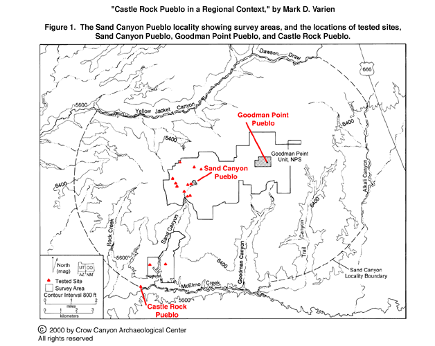
by Mark D. Varien
1
Castle Rock Pueblo was a small village inhabited in the late thirteenth century A.D. In this section I place Castle Rock
Pueblo within the larger social landscape of the Mesa Verde region. Archaeologists use the term settlement pattern to refer
to the geographical locations and distributions of archaeological sites. By recording the locations of sites relative to one
another and relative to various natural features, archaeologists are able to analyze settlement patterns and document how
those patterns changed through time. In this discussion of the social landscape, I begin by examining the area immediately
surrounding Castle Rock Pueblo, known as the Sand Canyon locality (Lipe 1992*3:2). Next I examine regional settlement patterns by
analyzing the distribution of community centers that date from the period
between A.D. 900 and
1300.
Settlement in the Sand Canyon Locality
2
Intensive survey (Figure 1) has been conducted in the upper Sand Canyon locality in the area surrounding Sand Canyon and
Goodman Point pueblos (Adler 1988*1, 1990*1, 1992*3; Van West et
al. 1987*1) and in the lower Sand Canyon locality, where Castle Rock
Pueblo is located (Adler and Metcalf 1991*1; Gleichman and Gleichman 1989*1, 1992*1).
Demographic trends for the Sand Canyon locality as revealed by these
surveys are summarized in Table 1. These data have
been synthesized and discussed elsewhere (Varien 1999*2) and
are only summarized here.
3
Surveys in the upper and lower portions of the Sand Canyon locality document similar demographic trends. There are
numerous sites that date from the Basketmaker III period (approximately A.D. 600–725/750) but fewer sites dating from
the Pueblo I period (A.D. 725/750–930). It appears as though the Sand Canyon locality may have been entirely abandoned
between the late A.D. 800s and the middle 900s—part of a widespread
depopulation of the Mesa Verde region at that time (Schlanger and
Wilshusen 1993*1; Varien 1999*1). The locality appears to
have been reinhabited sometime in the middle to late 900s, and the size of
the Sand Canyon locality population, as measured by the estimated number of
structures, increased into the 1200s (Varien 1999*1; Varien et al. 1996*1).
4
The upper and lower Sand Canyon locality surveys also document three general changes in settlement patterns between
A.D. 930 and 1300. The first was a change in the locations of habitations, the second was an increase in the average size of
habitations, and the third was a change from dispersed to aggregated communities. Between A.D. 930 and 1150, residential
settlements were located primarily in the uplands, where habitations were situated on the deep, wind-deposited soils that
are used for dryland farming today. Over time, canyon environments came increasingly into use, and by the 1200s most
habitations were located in canyon settings (Adler 1990*1:239; Adler and Metcalf 1991*1:47; Gleichman and
Gleichman 1989*1:42). The trend toward larger habitations culminated in
the 1200s with the formation of the villages of Sand Canyon Pueblo, Goodman
Point Pueblo, and Castle Rock Pueblo. The change in community form was
related to the change in the sizes of habitations. Beginning in the 900s,
communities consisted of loose clusters of small, dispersed farmsteads.
Over time these small habitations clustered closer together, resulting in
what Adler (1990*1:267) termed multi-roomblock habitation
sites. By the A.D. 1200s, the majority of the community was living in
large villages. These three changes—the shift in the locations of
habitations from upland to canyon environments, the increase in the size of
habitations, and the change from dispersed to aggregated
communities—were not unique to the Sand Canyon locality. The same
changes have been documented in every major survey conducted in the central
Mesa Verde region (Fetterman and
Honeycutt 1987*1; Greubel 1991*1; Hayes
1964*1; Neily
1983*1; Rohn 1977*1; Smith 1987*2).
5
Although the number of occupied locations in both the upper and lower portions of the Sand Canyon locality increased
throughout the Puebloan period (A.D. 1–1300), there was a marked difference in settlement patterns between the two, as
illustrated in Table 1. Specifically, the increase in occupied locations between the Pueblo II (A.D. 930–1100/1150) and
Pueblo III (A.D. 1100/1150–1300) periods was gradual and modest in the upper portion of the locality, but both rapid and
dramatic in the lower portion, particularly in the area surrounding Castle Rock Pueblo. It appears as though the villages of
Sand Canyon Pueblo and Goodman Point Pueblo developed after a long and relatively dense occupation of the upper Sand
Canyon area. Castle Rock Pueblo, on the other hand, appears to have developed in a local setting where earlier Pueblo II
habitation was relatively sparse, with little residential settlement before 1150. These differences are consistent with the
changes in the locations of habitations noted above; the upper Sand Canyon locality is a mix of upland and canyon settings,
but the lower Sand Canyon locality is predominantly a canyon environment.
Regional Settlement
6
To examine the regional settlement system, Crow Canyon archaeologists
have compiled something they call the community
center database. It includes an inventory of the largest sites and all
known public architecture in the region. Crow Canyon archaeologists began
this inventory in 1990 (Varien et al. 1996*1), and it is
continually updated and refined (Varien 1999*1). Information
about more than 130 individual community centers that were occupied between
A.D. 950 and 1300 is currently in the database. These sites are
interpreted as community centers because of their large size, their long
occupation
spans, and the presence of public architecture at many of them. Castle Rock Pueblo was one of these community centers.
7
In all periods, community centers were associated with clusters of smaller habitations located in the areas nearby. Early in
the A.D. 950–1300 period, most residents of communities lived in small, scattered farmsteads, and few people lived in the
community centers. Over time, an increasing proportion of each community's residents came to live in their respective
community centers. This trend culminated in the 1200s, when community centers became large villages in which most
community members lived.
8
The distribution of community centers can be used to examine the changing social landscape of the Mesa Verde region and
to characterize that social landscape during the final period of occupation, when Castle Rock Pueblo was in use. The
analysis of community centers began with the assignment of each center to
one or more periods of occupation (Varien 1999*1; Varien et al. 1996*1). Using tree-ring dates associated with
32 (23 percent) centers, Crow Canyon archaeologists assigned each to one of
four time periods: A.D. 950–1050 (Period 1), 1050–1150 (Period
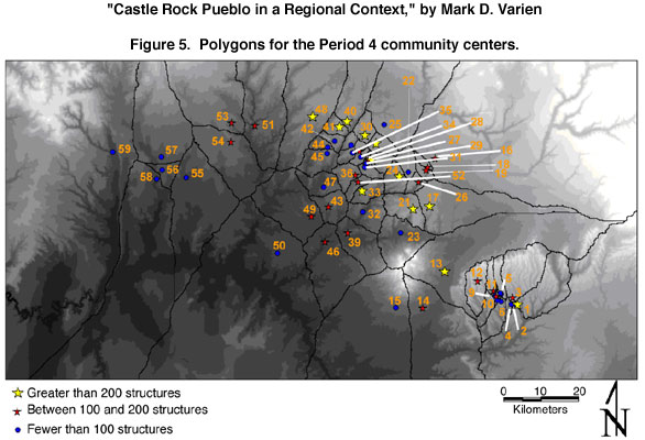
2), 1150–1225 (Period 3), and 1225–1300 (Period 4). Site
locations and layouts, as well as observations about the kinds of pottery
and architecture present, were then used to determine typical site and
community center "profiles" for each period. These profiles in turn
allowed researchers to assign community centers without tree-ring dates to
time periods on the basis of specific physical characteristics. Using
these methods, it was possible to assign two community centers to Period 1,
36 to Period 2, 44 to Period 3, and 59—all nucleated villages—to
Period 4. Eight community centers were assigned to more than one time
period because they had spatially discrete buildings that were dated to more than one period.
9
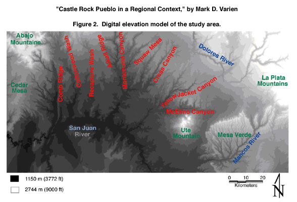
The second step in analyzing the community centers was to locate the sites on a digital elevation model (DEM) of the
region. The DEM contains elevational data for every 30-by-30-m cell in the region; these elevational data are illustrated in (Figure 2, in which the lowest elevations are shown in black, progressively higher elevations are shown in increasingly
lighter shades of gray, and the highest elevations are in white. To incorporate physiography into the analysis of the
distribution of community centers, geographical information systems software was used to convert the elevational data into
a friction surface on which every 30-by-30-m pixel on the DEM was assigned a value for the energy required to walk across
that surface.
10
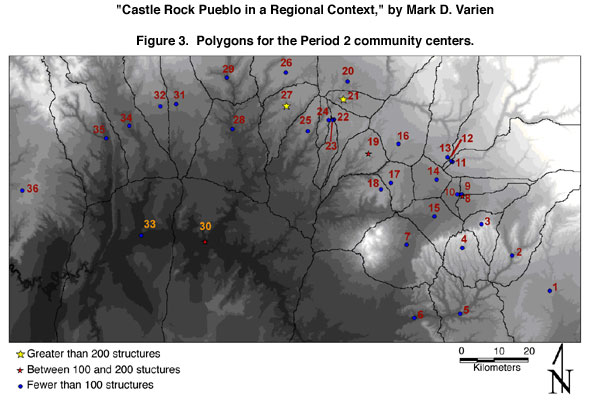
Community centers were plotted on this friction surface. The first analysis used the friction surface to produce a polygon
around each community center that took into account the difficulty of walking over variable terrain. In essence, the polygon
around a community center encloses the area that is closer to that community center than to any other center. The polygons
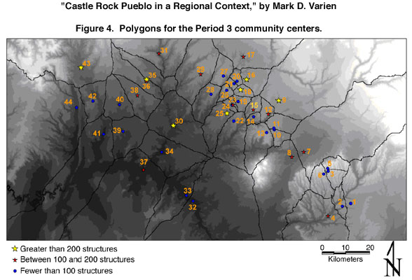
for the Period 2, 3, and 4 community centers are illustrated in Figure 3, Figure 4, and Figure 5, respectively, and the
corresponding community centers are listed in Table 2, Table 3, and Table 4.
11
These polygons illustrate several points about the social landscape of the Mesa Verde region. First, the locations of the
polygon boundaries show how the dramatic physiography of the region affected the potential for social interaction by
impeding pedestrian movement; many of the boundaries between community centers are shaped by the rugged terrain. This
is especially apparent in the polygon boundaries for Period 4, which are defined by major physiographic features such as
Comb Wash, Ute Mountain, the north rim of Mesa Verde, and a series of deep canyons between McElmo and Montezuma
canyons.
12
The polygons show another important pattern that characterized the changing social landscape of the Mesa Verde region.
Community centers were most evenly spaced during Period 2. In subsequent periods, community centers on the periphery
of the settlement system were abandoned, so that community center polygons in the peripheral areas increase in size over
time. In contrast, the number of community centers in the central Mesa
Verde region—the area between Mesa Verde and
Montezuma Creek (Lipe 1995*1:143)—increased through time,
and polygons in this area get smaller.
13
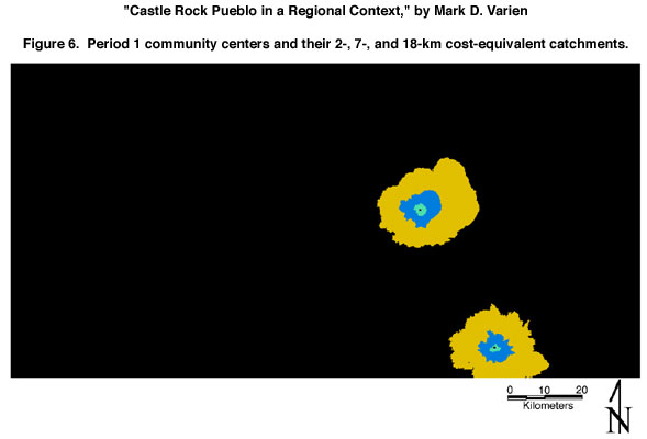
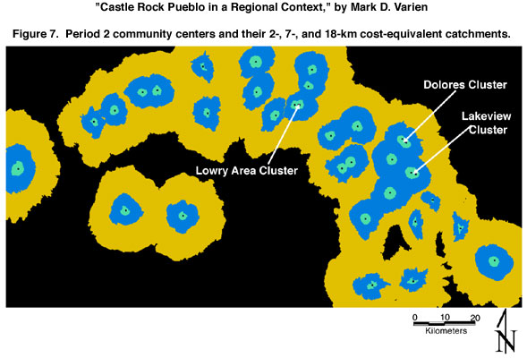
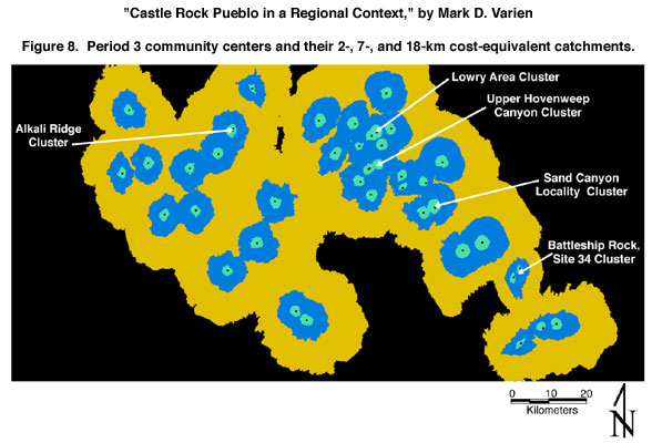
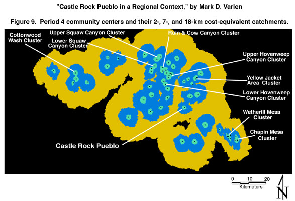
To examine the changing social landscape further, 2-km, 7-km, and 18-km catchments were placed around each community
center. These catchments are not defined on the basis of linear distance; instead, they use the friction surface and take into
consideration the energy required to walk each of those three distances over variable terrain. Figure 6, Figure 7, Figure 8,
and Figure 9 show the community center catchments for Periods 1, 2, 3, and 4, respectively.
14
These catchments correspond in a general way to how the territory around each community center would have been used by
people living in proximity to that center (Varien 1999*1).
The 2-km catchments are interpreted as the area around each community
center where residential settlement was most heavily concentrated and where
the most intensively cultivated agricultural fields were located. In
addition, people living within the 2-km catchment would have had regular
face-to-face interaction with one another. The 7-km catchment may have
been an area of less intensive agricultural use but one visited regularly
to gather wild plants, hunt wild game, and collect raw materials for a
variety of purposes. The 18-km catchment
reflects the approximate one-day, round-trip walking distance around each community center.
15
The catchments illustrate two important patterns in the changing social landscape of the Mesa Verde region. First, over time community centers became more closely spaced in the central Mesa Verde region, resulting in greater competition for
resources there. This increased competition would have been over a resource base that had been altered by several centuries
of human occupation. Second, the settlement system as defined by the locations of these community centers, which were
the largest and most persistently occupied habitations in the region, became increasingly isolated from settlement systems
in surrounding regions. These changes culminated during Period 4, when Castle Rock Pueblo was occupied.
16
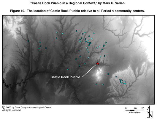
The Period 4 community centers were all nucleated villages (Figure 10). They usually were located in canyon
environments, close to springs, and they often had reservoirs designed to store water from rainfall and snowmelt. The
community centers typically were surrounded or partly surrounded by site-enclosing walls. In addition, most were
physically divided into two parts, usually by a drainage, but sometimes by a constructed wall. In the case of Castle Rock
Pueblo, the divider was the butte that separated the north and south sides of the village. Most villages appear to have been
associated with a larger community that included smaller habitations located nearby but outside the village-enclosing wall.
A recent review of community demography (Mahoney et al. 2000*1) indicated that approximately 70 percent of the
people living in the communities associated with these villages lived inside the enclosing wall.
17
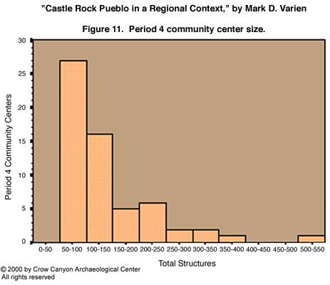
The villages varied in size. It is difficult to know the number of structures in each village without excavation, so the size
estimates are only general. The smallest villages contained between 50 and 100 rooms, and the largest Period 4 villages,
such as Sand Canyon Pueblo and Goodman Point Pueblo, had approximately 500 rooms. Figure 11 shows the size
distribution for these villages. The distribution is skewed to the left, with most villages having an estimated size of 50 to
100 structures (n = 60, mean = 130, standard deviation = 91.42). Castle Rock Pueblo had approximately 60 to 75 structures
(there is definite evidence for 16 kivas and 37 rooms), so it was among the smallest villages during Period 4.
Summary
18
Castle Rock Pueblo was occupied during the three decades preceding the final Puebloan migration from the Mesa Verde
region. In the century before these migrations, several dramatic changes took place in settlement patterns: the locations of
habitations changed from the mesa tops and rolling uplands to canyon settings; the sizes of habitations increased; large
villages were constructed; and community form changed from dispersed to aggregated. Castle Rock Pueblo reflects each of
these changes.
19
The regional social landscape changed along with the settlement patterns. Castle Rock Pueblo lay in the heart of the central
Mesa Verde region. By the time it was constructed, an increasing number of villages had crowded into that part of the
region. As a whole, the settlement system in the Mesa Verde
region—as defined by the largest and longest-lived villages—constricted in
size and became increasingly spatially isolated from settlement systems in
adjacent regions. Castle Rock Pueblo was therefore set in a social
landscape in which there was increasing competition over resources that had
been
degraded by several centuries of occupation.
20
As a village, Castle Rock Pueblo appears to have been constructed in an area lacking a long history of relatively dense
occupation. In this way, it differs from the nearby villages of Sand Canyon and Goodman Point pueblos. Castle Rock
Pueblo was a small village surrounded by much larger ones. Sand Canyon and Goodman Point pueblos, the villages located
closest to Castle Rock Pueblo, were more than five times the size of Castle Rock and may have been the two largest
villages in the Mesa Verde region between A.D. 1250 and 1290. As noted elsewhere in this report, there is a defensive
aspect to the architectural features at Castle Rock Pueblo (see "Architecture"). Increased competition for
resources may have contributed to the potential for conflict in the decades
before the final migrations from the Mesa Verde region. The small size of
Castle Rock Pueblo may have made this village particularly vulnerable to
conflict. Continued research is needed to clarify the relationship between
Castle Rock Pueblo and the nearby villages of Sand Canyon and Goodman Point
pueblos
and to determine who initiated the violence that ended the occupation of Castle Rock Pueblo.
References cited | To borrow, cite, or request permission
Permissions obtained: Figures 2–9 are slightly modified versions of illustrations first published in Varien (1999*1); adapted with permission of the University of Arizona Press. |
